
How novel use of GIS tools is helping Africa RISING – NAFAKA project in Tanzania to scale-out technologies in locations where they have the best chance to flourish
 Successful targeting of improved agricultural technologies is still a significant challenge hindering adoption of improved agricultural technologies. Traditional dissemination methodologies like the use of the extension systems or the establishment of demonstration sites have shown potential at localized scales, but there is a need for more cost-effective dissemination of technologies at much bigger scales through methodologies that complement and add value to the traditional dissemination styles.
A research paper published in the July 2017 edition of the Land Use Policy Journal has generated a considerable amount of interest after it showed the potential of geospatial tools in supporting evidence-based scaling of sustainable agricultural intensification technologies in Tanzania through the work of International Institute of Tropical Agriculture (IITA)-led Africa RISING-NAFAKA project.
The paper, which was authored by a team of scientists from IITA and partner CGIAR research institutes the International Food Policy Research Institute (IFPRI) and the International Center for Tropical Agriculture (CIAT), uses spatial data obtained using remote sensing satellites and geographical information systems (GIS) to delineate 20 relatively homogenous zones with similar biophysical and socio-economic characteristics. These zones should be targeted for scaling appropriate improved crop varieties and good agronomic practices in Tanzania.
The foundation of the research presented in the paper is premised on several years of research demonstrating that scaling-out agricultural technologies in sites with similar biophysical and socio-economic characteristics reduces the chances of failed use of technologies, thereby enhancing the likelihood of adoption. Zones with similar biophysical and socio-economic characteristics are referred to as recommendation domains.
Findings by this research greatly improve the existing recommendation domains in many aspects. First, the newly generated domains are ecologically sustainable since critical ecosystems such as nature conservation parks and wetlands were masked out to ensure scaling-out of agricultural technologies has minimal negative impacts on biodiversity and ecosystem services. The masked areas included Mikumi, Ruaha, and Udzungwa mountains’ national parks that are globally recognized biodiversity hotspots and water catchments with high vegetation biomass that store and sequesters significant amounts of carbon. Secondly, the new domains are generated using an objective data-driven approach compared to existing domains that were generated using subjective expert judgements.
Francis Muthoni of IITA who is the lead author of the paper points out that commonly used subjective descriptions of agroecologies such as ‘highlands’, ‘mid-latitudes’, and ‘lowlands’ will be a thing of the past, since they are not universal. ‘For instance, ‘highlands’ in Tanzania could be ‘lowlands’ in Nepal around Mt Everest,’ he adds. Such subjective classifications have limited potential for spatial extrapolation. The proposed method eliminates subjectivity making it easy to replicate in different ecologies provided that relevant input variables are available.
Furthermore, the article proposes an Impact Based Spatial Targeting Index (IBSTI) as an objective tool for priority setting when scaling agricultural technologies. IBSTI identifies priority areas within each sustainable recommendation domain that should be targeted to maximize potential impacts of a scaling intervention and enhances rationalization of limited resources. It helps to pinpoint priority zones with a high overall population, high poverty index, and number of women and children less than five years that are essential for targeting specific agricultural technologies. This index enables development agencies to estimate potential impacts of their technologies thereby supporting evidence-based site selection. This enhances effective allocation of limited resources and promotes achievement of greater impact especially for projects with a limited time span.
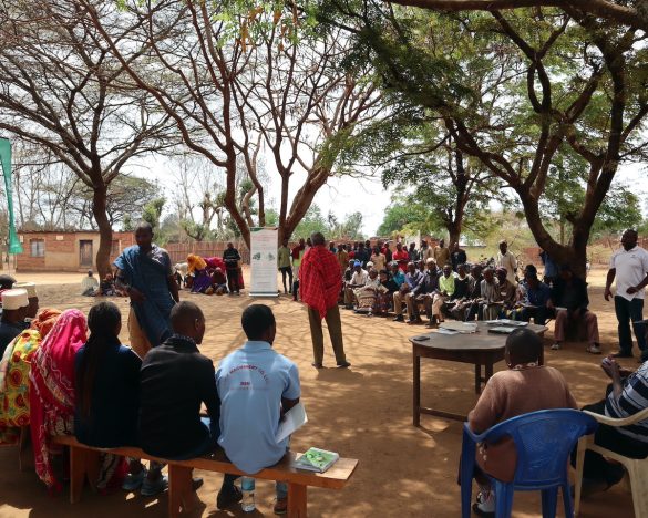
The opportunities for more effective, targeted scaling were manifest to the partners and donor representatives present at a recent Africa RISING̶ NAFAKA project partners meeting where the outcomes of this new publication were presented.
‘This information is very useful particularly for development partners to refer to when doing site selection. It may also be a good idea to integrate this GIS information into the protocols prepared by the different teams working in the Africa RISING-NAFAKA project to ensure that agronomists, for example, are able to use it in their work too,’ said the United States Agency for International Development (USAID) Tanzania Country Mission’s research and production advisor, Betty Maeda during the event.
The Africa RISING ̶NAFAKA project aims to carry forward the work on the use of GIS for targeted scaling in the coming years by identifying the sustainable intensification (SI) technologies that are suited for each of the 20 homogenous zones. Once appropriate SI technologies are allocated to each zone, the spatial index (IBSTI) will be used to pinpoint the high impact clusters. Demonstration sites will be targeted to these high impact zones to facilitate reaching a higher number of farmers. It is expected that the identified zones will form the central basis for planning project activities rather than the traditional way of focusing on administrative boundaries that have no ecological significance.